How to Cite: Cortés Sánchez, Luis Miguel, Javier Terrados Cepeda y Panu Savolainen. "Natural Discourses: The Awakening of Reima Pietilä's Ecological Consciousness". Dearq no. 43 (2025): 66-78. DOI: https://doi.org/10.18389/dearq43.2025.07
How to Cite: Cortés Sánchez, Luis Miguel, Javier Terrados Cepeda y Panu Savolainen. "Natural Discourses: The Awakening of Reima Pietilä's Ecological Consciousness". Dearq no. 43 (2025): 66-78. DOI: https://doi.org/10.18389/dearq43.2025.07
Luis Miguel Cortés Sánchez
Universidad de Sevilla, Spain
Javier Terrados Cepeda
Universidad de Sevilla, Spain
Panu Savolainen
Aalto University, Finland
Received: September 15, 2024 | Accepted: April 24, 2025
The 1960 publication of "Études de morphologie en urbanisme" by Reima Pietilä marked a milestone in the process of theoretical experimentation grounded in the pursuit of harmony between humans and the landscape through urban planning and architecture. The ambiguity surrounding the origins of Pietilä's ecological awareness motivates this article, which aims to trace the emergence and contextual development of his interest in the landscape dimension at the urban scale. Drawing on previously unpublished materials from the archives of the Museum of Finnish Architecture (MFA), the research concludes that Pietilä's participation in CIAM X (1956) was a critical turning point, and that the Märsta-Valsta Master Plan competition (1961) constituted the first practical application of his theoretical ideas, both of which are analyzed in detail in this article.
Keywords: Urban planning, landscape, Finland, rural environments, CIAM X, Pietilä, Märsta-Valsta.
The landscape-oriented lens through which the work of Raili and Reima Pietilä has often been interpreted is nothing new. According to the architects themselves, this relationship with the landscape has become a recurring theme in the majority of studies on their professional trajectory. However, much of this research has concentrated on the analysis and dissemination of their major works, such as the Dipoli building and the Mäntyniemi Presidential Residence. In contrast to the consistent architectural scale of these projects, Raili and Reima Pietilä's contributions to urban planning have received comparatively little scholarly attention. This is likely due to the fact that most of their urban projects remained unbuilt and, as a result, never moved beyond the conceptual stage.
Even so, it is noteworthy that Reima Pietilä's first major theoretical proposition—later presented in the exhibition Morphology and Urbanism—focused specifically on the scale of urban planning. Retrospectives on his work have tended to overlook the projects from his earlier solo period, during which he began to demonstrate a clear interest in natural elements and ecological perspectives that would later become central to his designs.
This article seeks to revisit the moment when Reima Pietilä first expressed his interest in the ecological dimensions of urban planning and architectural design. It begins with his contribution to the CIAM X Congress in Dubrovnik (1956), where he participated as a member of the Progrès Technique Architecture Helsinki (PTAH) group. Predominantly theoretical in nature, this contribution outlined key principles that would later inform his professional practice. To complement this theoretical foundation, the article also examines the earliest applications of these ideas in his architectural work. In 1961, Pietilä's proposal for the Märsta-Valsta Master Plan competition in Sweden marked the first translation of the postulates he had defended into a practical project.
To this end, the research draws on unpublished materials housed in the archives of the Arkkitehtuurimuseo (Museum of Finnish Architecture, MFA). These documents serve as the foundation of the study and are supplemented by historical data from both documentary and bibliographic sources. The methodology prioritizes the exploration of previously unpublished writings and drawings as a means of understanding and interpreting the conceptual processes that informed Pietilä's theoretical positioning. This approach supports the development of the analyses and connections presented in the article along two main axes: first, a consolidated account of Reima Pietilä's early landscape theories; and second, their subsequent translation into urban design projects.
The awakening of Reima Pietilä's ecological consciousness, closely tied to the formal reinterpretation of natural elements, stands out as one of the most significant theoretical aspects of his architectural work. This evolving theoretical discourse first gained visibility through his participation in CIAM X, held in Dubrovnik in 1956. Prior to this, a series of preparatory meetings laid the groundwork for the congress. Pietilä's involvement began in 1954 when he was invited to join the Finnish group PTAH–CIAM by Aulis Blomstedt, who brought his own theoretical convictions to the group, particularly the notion of form as a factor as fundamental as content. While Reima Pietilä initially aligned with Blomstedt's position, he gradually redirected his focus toward morphological studies centered on natural and landscape components. This shift gave rise to a theoretical discourse grounded in ecology and the relationship between urban and rural environments. These early formulations would later serve as a foundation for subsequent reflections on ecological consciousness in urban studies during the second half of the twentieth century, positioning Reima Pietilä as a key intellectual figure in the history of modern architecture in Finland.
The CIAM X congress marked a turning point in the integration of territorial considerations into urbanist discourse, emphasizing the interaction between architectural proposals and the landscape, and placing human association at the core of urbanism. In the document Habitat: First Proposal of CIAM, Conclusions and Resolutions, the committee recommended the creation of specialized commissions tasked with addressing clearly defined thematic areas (fig. 1).

Figure 1_ Commissions established for CIAM X, approved at the Padua council on August 3, 1956. Source: MFA.
Reima Pietilä participated in Commission B.5, which focused on the issue of mobility, contributing his proposal titled The Relationship Between Man and Traffic in Special Geographical Settings. In the PTAH report presented at the CIAM Council meeting in La Sarraz in September 1955 (Pietilä 1955), he had already emphasized the importance of grounding proposals in the specific cultural context of each group. Building on this premise, Pietilä addressed the issue of mobility through a distinctly Finnish lens, drawing on his personal reflections on the Arctic landscape. He proposed underground mobility—sheltered from extreme weather conditions—as a solution for connecting emerging urban centers in rural areas. Viewing the city as a complex ecosystem in which any intervention affects the whole, Pietilä advocated for a holistic approach that carefully balanced the interrelationship between urban development and the natural environment.
Reima Pietilä presented his proposal through four panels outlining an urban growth strategy aimed at enabling targeted territorial occupation through residential clusters of varying scales. The design of these clusters was informed by a reinterpretation of the site's landscape conditions. Among the factors emphasized by Pietilä—frequently depicted in his drawings—were topography and vegetation, followed by additional geographical elements such as orientation and prevailing winds.
At the PTAH–CIAM meeting held in Helsinki in April 1955, Reima Pietilä presented a preliminary version of what would later become his official submission to the Dubrovnik congress. The volume of information generated during this process—combining both texts and drawings—enabled Pietilä to organize and develop his emerging theoretical ideas. Among these, the concept of a Town Without Streets stands out (fig. 2). The accompanying drawings suggest that the defining feature of this model was the extension of the natural landscape between built structures, positioning these continuities of nature as the organizing pattern of the urban design. This intention is clearly expressed in Pietilä's annotation: "streetpattern as a prolongation of landscape, streetpattern as a geographical scale." To achieve this town without streets, isolated buildings had to be arranged in a fragmented manner, maintaining direct contact with the rural environment and deliberately avoiding the imposition of urbanizing structures on the landscape.

Figura 2_ Reima Pietilä, 1955. Left: Diagram of the idea of a Town Without Streets. Right: Water as an Element of Prolongation. Source: MFA.
The intention to extend the landscape within the urban proposal is evident in Pietilä's theoretical submission presented in Dubrovnik, which stemmed from a broader reflection on the human values essential to inhabiting a given territory. His annotations advocate not only for the integration of natural forms but for their preservation: "By protection of geographical forms. By accommodation, the human constructions to the geographical (scale) surroundings / in relation to the characteristic traits of them" (fig. 3). Finnish culture has historically found refuge in the rural environment (Cuéllar Jaramillo 2017)—a cultural context that informs Pietilä's prioritization of rural features over urban transformation. Even at this early stage, he considered the use of underground space to house functions that might disrupt the rural landscape and emphasized the importance of regulating mobility—an approach that would go on to define the core principles of his later theoretical work.

Figure 3_ Reima Pietilä, Establishment of Human Values, 1955. Source: MFA.
Pietilä justified the implementation of an underground mobility system on technical, psychological, and aesthetic grounds. Technically, he emphasized the need to protect communication routes from the harsh Arctic climate, which contributed to road deterioration and high maintenance costs. Placing infrastructure underground, he argued, would mitigate these issues, while also being feasible given the self-supporting nature of Finland's granite soil. From a psychological perspective, Pietilä maintained that vehicles were a source of disturbance, and that their concealment was essential to ensuring quality of life in an increasingly mechanized world. Finally, his proposal incorporated an aesthetic dimension, about which he was categorical:
Architecture has to express the fundamental relations of man and earth. Through architecture man can enjoy the amenities of the nature and those of cultivation only in that case that he does not crowd his surrounding too much with mechanical production means, it is true quite essential for his culture and his survival. Surroundings, urban or rural is the very 'living room' of man, place for cultivation and growth, not a chemical laboratory or a dentist office. Habitation is to be a connection point between cultivation and nature, it should find the place between fields and forests in the Finnish landscape (Pietilä 1956).
Given the limited scope of his built work at that time, Pietilä did not provide concrete examples. Instead, he synthesized the key aspects of his proposal through twenty illustrations distributed across four panels.

Figure 4_ Reima Pietilä, Plate 1. "General Study Concerning Relations in an Urban Unit. Frame: Socioeconomic Whole of Towns", Dubrovnik, 1956. Source: MFA.
The series of illustrations in the first panel (fig. 4) allowed Pietilä to present the core principles of his mobility proposal: a concentric system composed of multiple rings of connectivity, whose primary innovation lay in its relocation to the underground level.
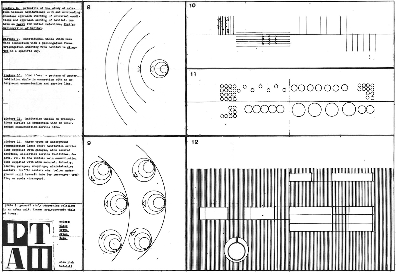
Figure 5_ Plate 2. "General Study Concerning Relations in an Urban Unit. Frame: Socioeconomic Whole of Towns", (Dubrovnik, 1956). Source: MFA.
The second panel (fig. 5) enabled Pietilä to explore the relationship between the interconnected settlements and their surrounding landscape (figs. 8 and 9). This connection is proposed through the deliberate placement of built volumes on the site. Various housing typologies are organized along a central longitudinal axis, connected by an underground line dedicated to circulation and services (figs. 10 and 11).

Figure 6_ Reima Pietilä, Plate 3. "General Study Concerning Relations Between Urbanic and Rural Characters", Dubrovnik, 1956. Source: MFA.
The diagrams in the third panel (fig. 6) take on a distinctly architectural and urban character. Under the title General Study Concerning Relations Between Urbanic and Rural Characters, Pietilä highlights the contribution of the rural landscape to urban discourse. Through graphic representation, he distinguishes between two contrasting realities: on the one hand, the regular, geometric world of settlements—represented by a circle—and on the other, a profile reminiscent of an electrocardiogram, used to depict the variability of the geographical environment (scheme 13). Diagram 14 shows a cluster of interconnected housing units, shaped by the constraints of the surrounding geography; rather than circular forms, the urban settlements appear as varied rectangular polygons. The Arctic landscape becomes the central theme of this reflection, underscored by Pietilä's annotation: "Special Finnish geographical form: lakelandscape and a composition factor in general layout of constructed environment. This whole situation can be comprised as a prolongation of habitat."
Diagram 15 demonstrates how the surrounding landscape—depicted in white—influences the configuration of the settlements, determining both the form and sequential arrangement of the built volumes along the site's perimeter. This approach also facilitates the identification of optimal areas for locating residential clusters. Pietilä's perspective aligns with the holistic approach of Patrick Geddes's valley section; (1915), viewing urban developments as living organisms embedded with and responsive to their natural, social, and cultural context. In this view, topography, vegetation, and human activity are integrated into a cohesive, harmonious whole (Clavel and Young 2017; Batty and Marshall 2017).

Figure 7_ Reima Pietilä, Plate 4. "General Study Concerning the Character of Building in Rural Environment", Dubrovnik, 1956. Source: MFA.
The fourth panel focuses on the architectural character of the proposed buildings within the rural landscape (fig. 7). The design of these structures is directly informed by their relationship to the surrounding environment. Pietilä proposes taller structures whose primary occupancy is located below ground level, thereby reducing the visual impact of the built elements and preserving the integrity of the landscape.
The minutes of Commission B.5 (CIAM X / LAPAD 1956) reveal divergent perspectives among participants, underscoring the contrasting positions held by Pietilä and his colleagues. While many participants were captivated by modes of transport—and, consequently, their visibility—this enthusiasm clashed with Pietilä's proposal to conceal infrastructure underground. This fundamental misunderstanding was a key source of disagreement. Only Aldo van Eyck expressed support for Pietilä's vision (Norri and Pietilä 1985). In the end, the debate centered on the issue of subterranean mobility, overshadowing the proposal's true innovation: the idea that the rural landscape could offer the compositional foundations for a new form of urban planning, as well as for the design of its architecture.
Despite the lack of consensus, Pietilä continued to develop his theoretical work. In 1960, in addition to publishing his article Études de morphologie en urbanisme par Reima Pietilä (Pietilä 1960) in the journal Le Carré Bleu, he organized the exhibition Morphology - Urbanism (Pietilä 1985) (fig. 8).

Figure 8_ Études de morphologie en urbanisme par Reima Pietilä. Source: Le Carré Bleu.
This exhibition marked not only a milestone in Reima Pietilä's career but also a pivotal moment in the Finnish architectural discourse (Pelkonen 2019). His theory of morphological urbanism was presented as an alternative to what he described as the prevailing deplorable approach of the time (Pietilä 1985, 58). He criticized dominant urbanism for its proliferation of standardized, repetitive, and impersonal constructions—buildings that, in his view, could be replicated indiscriminately anywhere in the territory, devoid of any architectural specificity. In response, Pietilä used this exhibition to contrast these two models, highlighting the advantages of his proposal, which advocated for forms derived from natural elements of the environment, such as topography and vegetation. To support this argument, he included illustrations of his alteration process, as well as comparative examples of conventional urban growth—juxtaposing, on one side, the orthodox model, and on the other, his landscape-based strategy (fig. 9).

Figure 9_ Comparison of urban growth. Left: Orthodox model. Right: Strategy proposed by Pietilä. Illustrations from the exhibition Morphology – Urbanism, 1960. Source: MFA.
All of this contributed to Pietilä's development of a clear stance regarding urban design (Pallasmaa 2009). However, at that point, he had not yet had the opportunity to test its viability within the context of a built project (fig. 10).

Figure 10_ From left to right: Illustration presented at CIAM X, 1956; illustration from the exhibition Morphology – Urbanism, 1960; photograph of the model for the Master Plan of Märsta-Valsta, 1961. Source: MFA.
Parallel to his theoretical development, Reima Pietilä also began to build his career in urban planning. In 1953, shortly after graduating as an architect, he joined the Helsinki Town Office (Connah 1989). However, it was not until the 1960s that he began to engage seriously with large-scale urban design. In 1961, he had the opportunity to apply his ecological urban planning approach by participating in a competition to design the master plan for a new residential area in the Swedish city of Märsta.
The call for proposals for the Märsta-Valsta competition was grounded in the same premise that underpinned Pietilä's theoretical discourse at CIAM X: the creation of a new urban settlement within a rural landscape, interconnected with surrounding suburban areas.
The decision to expand Stockholm-Arlanda Airport near Märsta served as a catalyst for the city's growth. The commission responsible for planning the new town appointed Hakon Ahlberg as the lead architect for drafting the master plan (Bøggild 2017). Märsta was geographically defined by its location in a valley surrounded by four hills, each designated for future urban expansion (fig. 11 [left]). Although a general plan was already in place, the design of the largest of these hills—Valsta—was opened to an architectural competition, in which Raili and Reima Pietilä participated. The objective was to develop this southwestern area of the city as a residential district intended to accommodate approximately ten thousand inhabitants.

Figure 11_ Left: Topographic plan of the area. Right: General Master Plan for the city of Märsta, Hakon Ahlberg, 1960. Source: the author and MFA.
The general plan proposed a conventional layout for the area and was provided to competition participants as a reference document. Although the version included in the annex lacked detailed topographical information, the copy preserved in Reima Pietilä's archive contains small annotations and sketches that reveal his sensitivity to the site's physical characteristics. Notably, a drawing of the highest mound in the southern part of the intervention area (fig. 11[right]) reflects his concern with engaging the actual landscape. This attention to topography gains further significance when considered alongside the annexed contour map (figs. 12 and 13). Pietilä's search for a design that would formally respond to the rural environment's morphology began with this premise: addressing the site's topographical features was essential for fulfilling the competition's requirements.

Figure 12_ Left: Topographic map of the site with boundary of the intervention area. Competition annex, 1961. Right: Superimposition of the model onto the site, ca. 1960. Source: the author.

Figure 13_ Photograph of the site prior to the competition, ca. 1961. Source: MFA.
The Pietiläs proposed a layout that departed radically from the general plan. Their approach prioritized alignment with the site's topography as the guiding principle for defining intervention areas, treating the geographical features as central to the organizational logic of the design. They identified the primary elevations of the terrain as key starting points for the urban design. Based on this analysis, they proposed a single axis connecting the highest points, upon which a common framework of built volumes—limited to three stories—would be organized longitudinally. The residential program was arranged in linear vertical blocks, oriented perpendicularly to this main axis, with a primary roadway serving as the structural spine of the overall scheme (fig. 14).

Figure 14_ Overlay diagram of the elements: frameworks and devices, based on the model. Source: the author and MFA.
The site's location at the top of the hill required careful consideration of how to connect the new development with the rest of the town, particularly in light of ongoing debates about the integration of housing and automobiles within a community spanning approximately 200 hectares. To address this, Reima Pietilä drew on the mobility schemes he had previously developed for Dubrovnik. The proposed urban expansion was conceived as a system of interconnected clusters of built ensembles at varying scales, organized along a primary circulation axis that branched into secondary comb-like routes (fig. 15 [top]).
Raili and Reima Pietilä addressed the expansion of the development by combining and modifying a primary framework, to which they attached adaptable components that allowed the scheme to be replicated at different scales and positions, in response to the specific conditions of each site.

Figure 15_ Raili y Reima Pietilä, 1961. Top: Initial sketch of the proposal. Bottom: General layout of the proposal. Source: MFA.
As in the Dubrovnik proposal, the common framework functions as an equipped platform that houses shared facilities and serves as a connective spine for the entire complex—an element conceived as an interchange, facilitating transit and circulation. These spaces were envisioned as vibrant zones bustling with activity, energized by commercial modules integrated within the platform and by the inclusion of internal parking areas.
In the documentation submitted for the competition, the Pietiläs included a portion of the layout at a smaller scale. This drawing reveals the extent of the proposed framework, with labelling indicating designated uses such as commercial and parking areas, although these elements are not defined in detail (fig. 16 [left]). In contrast, the preparatory sketches offer greater insight into the spatial conception of these areas. Figure 15 (bottom) illustrates how the proposal is organized around a main road, from which a network of branches extends to provide access to smaller clusters. Within these clusters, the road leads to the common framework, envisioned as a multi-level structure. From this central platform, a series of secondary pedestrian routes emerges, completing the internal circulation system (fig. 16 [right]).

Figure 16_ Raili and Reima Pietilä, 1961. Left: Area developed for the competition. Right: Organization schemes based on mobility. Source: MFA.
The design of the components connected to the platform emerged from careful negotiation between topographical conditions and mobility criteria. In relation to the topography, the residential volumes were conceived to assert the strength of the proposal rather than to camouflage or mimic the terrain's natural profile (fig. 17). In the early design phases, Reima Pietilä explored various configurations to address the relationship between the hillside and the architectural intervention. The stepped arrangement of the volumes enabled a dynamic interaction with the terrain, simultaneously replicating and transforming it. The result was an artificial skyline that echoed the natural landscape, evoking the image of a geological efflorescence.

Figure 17_ Raili and Reima Pietilä, 1961. Sketch defining the interaction between the built volumes and the topography. Source: MFA.
Finally, the architects opted for the most disruptive option, proposing volumes that rise prominently from the landscape in vertical symmetry with the underlying topography, aiming for a sense of exuberance. These elements emerge from the supporting framework and respond to the terrain's topographical differences by increasing in height toward their extremities, reaching façades as tall as forty meters. Across the initial sketches, a consistent compositional strategy can be observed—one that integrates both horizontal and vertical dynamics of the proposal (fig. 18).

Figure 18_ Raili and Reima Pietilä, 1961. Different volumetric proposals in section. Source: MFA.
These initial drawings suggest an architecture more anchored to the land, where horizontal dynamics play a central role in shaping the buildings' configuration. In the sketches presented in figure 18, the height of certain volumes corresponds closely to that of the supporting structure. However, in the final proposal submitted for the competition, the architecture is defined by volumes that appear to emerge from the terrain rather than remain rooted within it (fig. 19). The recessed junction between the lower levels and the ground accentuates this effect, reinforcing the idea of the building as a geological outcrop pushing forward from the landscape.

Figure 19_ Raili and Reima Pietilä, 1961. Sections of the proposal submitted to the competition. Source: MFA.
Despite the originality of Raili and Reima Pietilä's proposal (fig. 20) in both urban layout and architectural design, they did not receive any awards in the competition, which was ultimately won by Erik Ahnborg and Harald Mjöberg from Vattenbyggnadsbyrån (VBB). Nevertheless, their entry marked one of the first concrete attempts to translate the theoretical discourse Reima Pietilä had previously presented into a specific architectural project. The Märsta-Valsta competition represented the initial application of this urban theory to a real design context. Although the proposal was not selected, it proved to be a pivotal experience that informed the development of later projects by the duo, including the Suvikumpu residential complex (1962–69).

Figure 20_ Raili and Reima Pietilä, 1961. Exterior perspective of the general layout of the proposal. Source: MFA.
This research has demonstrated that the theoretical contribution of the architectural duo had its innovative origins with Reima Pietilä's participation in CIAM X in Dubrovnik (1956), where he first articulated the foundations of what would be later developed as "morphological urbanism", particularly in his 1960 publication in Le Carré Bleu. A superficial reading of the Pietiläs' work—one that interprets the distinctive forms of their architecture and the apparent dissolution of their buildings into the landscape as products of an intuitive professional approach—must be reconsidered in light these early theoretical antecedents. Rather, their naturalistic design was already rooted in a conceptually grounded position, anticipating what could now be described as a form of landscape urbanism avant la lettre.
This analysis of Reima Pietilä's theoretical beginnings, undertaken with the aim of temporally locating the emergence of his ecological awareness, has not only identified its initial articulation in his 1956 proposal for CIAM X, but has also revealed that the process through which his awareness developed is equally significant. The study of both the preparatory materials and the formal content of his contribution has uncovered previously unstudied conceptual explorations by a young Pietilä. Among these, his reflections on the notion of designing "cities without streets" and the idea of extending the landscape as a pattern for urban planning; are particularly noteworthy—early studies and approaches that remain highly relevant today.
In this regard, this article has shown how Reima Pietilä recognized the potential of natural patterns and began to explore the possibilities offered by this emerging perspective. His contribution to CIAM X reflects an interpretation of the Finnish landscape as a guiding force in the distribution of ex novo urban growth within natural settings. The research has recovered and brought to light his studies, which focus, among other aspects, on the transformation of basic geometric structures through the influence of natural forms—structures shaped directly by the physical conditions of the site. Consequently, the work also reveals how these landscape-driven considerations informed the scale of architectural design.
All of these ideas gradually coalesced into what Pietilä later formalized in 1960—first through his article Études de morphologie en urbanisme, and subsequently in the exhibition Morphology and Urbanism. However, due to the limited impact of his urban-scale projects, the translation of these theories into concrete urban proposals has attracted little attention from contemporary researchers. This study emerged from that identified gap: the lack of analysis of actual, rather than merely theoretical, urban projects in which Reima, and later, in collaboration with Raili, sought to apply these theoretical principles.
While the connections between the exhibition Morphology and Urbanism and the Suvikumpu project are well established, it was not there that Pietilä's theoretical approach was first put into practice. This article's consideration of the full proposal for the Märsta-Valsta Master Plan competition in 1961 reveals, for the first time through its graphic documentation, the concrete application of these theories within the context of an architectural competition. The concepts of the "city without streets" and the extension of the landscape as a pattern found their initial expression in this project and remain strikingly relevant today. In fact, contemporary theoretical currents, led by figures such as James Corner and Charles Waldheim, advocate for a closer relationship between humanity, urbanism, and nature. Whether consciously or not, these approaches resonate with Pietilä's early interest in embedding landscape logics within urban planning and in conceiving nature as a pattern within the design of urban systems.
The Märsta-Valsta proposal already placed a strong emphasis on fostering a harmonious relationship with the environment, redefining conventional urban practice by decisively softening the boundaries between the urban and the rural. In a rigorous continuation of the principles Pietilä had previously defended at CIAM X, the project positioned the natural landscape as the fundamental basis for human habitation, asserting that new urban developments must respond to this reality from their very inception.
This inquiry has been conducted within a cultural context increasingly receptive to its themes, marked by the now irreversible urgency of respecting and rehabilitating the natural environment, the growing number of proposals aimed at the renaturalization of cities, and the rise of so-called landscape urbanism. This emerging field advocates for the integration of insights from disciplines directly engaged with nature into the design of the physical environment that shape human settlements.