Introduction
The book Quito: A flatbed site as an agent for a new centrality curated in 2007 by Joan Busquets and Felipe Correa, became one of the most relevant academic publications for the development of a project to foresee the relocation of Quito’s international airport. Busquets advised of the importance and need of an “Urban Project”, intentionally with capital letters, and of “putting together a more ambitious strategy” and new “models of urban projects”, which “Quito needs and needed at the time, new forms of public-private collaborations, new green ecologies and others that could “represent its former lacustrine conditions”, as well as becoming an opportunity for addressing needs at the local and city level. In this publication, Busquets defines the Urban Project as a “discipline”, as “general guidelines followed by various developments that remain strongly independent in functional, programmatic, and temporal terms, though subject to the same overall planning composition” (Busquets and Correa 2007, pg.20).
Its construction goes hand in hand to regenerate the surrounding area, transforming a place that grew around the airport and that, due to restrictive urban regulations and environmental detriment (Castillo et al. 2019), maintained low building heights and low surplus-value. The airport’s relocation becomes a great opportunity for a significant transformation of this area. Although presently there are several processes in motion for constructing this park and for obtaining economic benefits from it, almost thirteen years after a design ideas competition was held and eight years after the approval of an order that regulates the surrounding area’s urban transformation, there is not a significant evolution from these processes.
This reflection paper proposes the analysis of the transformation of Quito’s former airport into Parque Bicentenario through primary sources, such as official orders, documents from the international design ideas competition for the park, its winning proposal and subsequent modifications, site-specific decisions, policies, and projects. It critically analyses the intention of keeping this large void unbuilt and transforming it into a great urban, environmental, social, and economic resource for the city, identifying the voids that exist within the political-administrative and design processes. It studies this proposal through the lens of constructing Large Urban Projects (LUP) (Lungo 2002, 2007), and within it to define several research questions to evaluate the process, its results, and the status in which the construction of this park is currently at. As conclusions and suggestions, it proposes some contributions to the discussion not only specific to Parque Bicentenario but in a broader framework to the current situation concerning LUPs and to the construction of open spaces in the contemporary Latin American city.
Theoretical Framework
The culture of the Urban Project in the contemporary city
Urbanism and urban planning emerge together with the contemporary city, an increasingly complex, multidisciplinary field that transcends the physical and spatial. This is “an interstitial space … where different points of view are cultivated and are capable of apprehending multiple urban dimensions; it moves between contingency and vision, between the past, the present, and the future, between technology and politics, between politics and government” (Gabellini 2018).
This work uses the Italian academic line of thought, built collectively through an active reflection on urbanism, the ethos of the project, the context, and all the dimensions that make up the city and the action of planning it. This reflects on the role of the Urban Project in the construction of the contemporary city. In 1991, Macchi Cassia published one of the first analyses on the Urban Project through the first significant cases implemented in the previous decade. He highlights the capability of management to be understood as the ability to integrate actors from various urban realities, to strengthen political and civil relations, and to enrich the city with new symbols and environmental improvement. Antonella Bruzzese and Laura Montedoro (2015) emphasise the need for the Project to be “guided, adapted and constantly redesigned”, and to have a leading figure with a role that is not limited to drawing the space, but to “delineate a process”.
Large Urban Projects
LUPs have emerged in the last four decades as a strategy of spatial and economic revitalisation that has challenged several dimensions of urban planning, mainly for their magnitude in size and scale; often requiring exceptional regulations and new mechanisms and instruments to enable them (Moulaert, Swyngedouw and Rodríguez 2002; Lungo 2007; Bricocoli and Savoldi 2010). Their insertion within the context and planning processes has triggered several analyses that define them as a tool (Macchi Cassia 1991; Lungo 2002; Wagner 2014), an urban policy (Moulaert, Swyngedouw and Rodríguez 2002), a method (Cecchini 2004), a project that attempts to create a new urbanity (Majoor 2008) or a form of knowledge production (Vigano 2011).
LUPs are generally characterised by three aspects: 1) the symbolic importance of the project within its context, several scales, and an extended timetable, 2) multiplicity of actors, cooperation between public-private entities especially within the economic and political dimensions, 3) delimited area of intervention with a defined programme, hence the challenge of inserting the project within its context (Cecchini 2004; Lungo 2007; Majoor 2008; Wagner 2014; Gabellini 2018).
Several aspects have contributed to the rise of LUPs, such as the redevelopment of large industrial areas, new industries, major world events, neoliberal policies in the real estate market, economic incentives, globalisation, deregulation, global competition between cities, cities networks, among others (Macchi Cassia 1991; Lungo 2002, 2007; Moulaert, Swyngedouw and Rodríguez 2002; Majoor 2008; Ponzini 2008; Wagner 2014). In Latin America, this type of process entails an even more critical social dimension, since these projects tend to target elitist social classes, and when they are implemented within inhabited areas, they threaten the displacement of the most vulnerable classes. Besides, it is a challenge to manage and finance these large projects, which require continuous administrative processes that rely mostly on private capital, often from foreign sources (Lungo 2002).
Parque Bicentenario visibly fits within the three fundamental aspects that characterise LUPs: symbolism and scale, multilevel governance, and a specific intervention area. This literature review highlights three aspects for the analysis of the Parque Bicentenario: context, management, and design. 1) The context is understood through the Project as a complex space for knowledge production, in which an interpretation of the city is built, and where new spaces, ecologies, and relationships are produced. 2) Management is used as a tool for integrating various voices from different backgrounds and interests and to conduct an open process in constant evolution and adaptation. 3) the importance of Design within the process to achieve an effective spatial transformation that considers its economic, social, and political variables.
What happens if we analyse the process of Parque Bicentenario within these frameworks? Can we conclude that there is an Urban Project designed for Parque Bicentenario? Does the current process respond to a theoretical framework or model? Can we approach it from the framework of the LPUs? Is it still possible to do so? And how appropriate is it?
Analysis of primary sources
Parque del Lago: Design
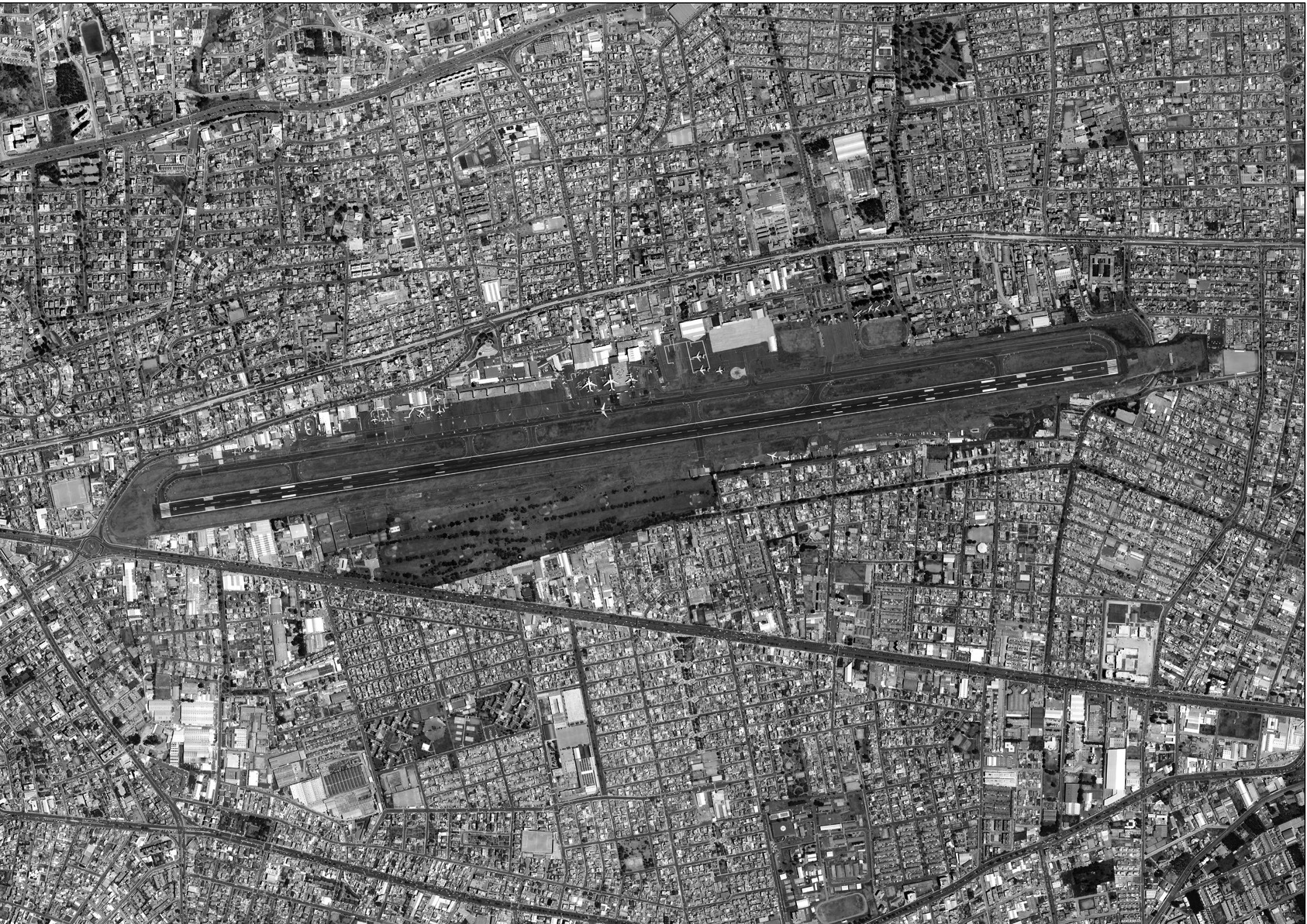
In 2008, the Municipality of Quito launched the international design ideas competition Parque del Lago on the former site where Quito’s international airport operated since 1960. The decision to relocate emerged as a result of the city’s rapid expansion in the second half of the twentieth century, in which the airport became surrounded by a melting pot of low residential buildings which physically reached its perimeter. In February 2013, the airport was officially moved to the nearby valley of Tumbaco. This process opened the possibility of rethinking the northern areas of the city, environmentally tainted by noise and pollution (Castillo et al. 2019).
The competition guidelines (2008) called for the design of a 126 hectares park to promote the “most ambitious articulated urban development process in the city where eco-urbanism is applied through a process of re-composition of the city”, by proposing four main aspects:
“a) To expand the provision of public spaces for recreation, leisure, and meeting for the inhabitants through a landscape-oriented large contemporary public facility; (b) to improve the cross-sectional (east-west) connectivity; (c) to adapt the urban structure affected throughout the years by airport restrictions; and (d) to improve and repair existing environmental conditions.”
The selected winning proposal belonged to the architects Ernesto Bilbao and Robert Sproull Jr. (2009) from work developed within an academic studio. Inspired by the work of James Corner, they proposed a landscape transformation that sought to replicate in the 3.4 kilometre site’s length, an ecological effect that occurs within 45 kilometres, from the north to the south of Quito’s upper plateau. In this span, and at an average altitude of 2,800 metres, the vegetation and climate change radically. In the southern areas, the project places forest-like vegetation and water features, and in the northern areas, urban orchards and dry vegetation zones. Additionally, it prioritises pedestrian connections at ground level to accentuate the existing road structure by creating three vehicular underground passageways. It aims to preserve the physical integrity of the entire site. Another aspect was the location of cultural facilities in the area where the old airport terminal functioned. Therefore, it minimised the number of buildings so the rest of the park could have a predominant landscape image through an extended conversion process that replaces the airport’s hard asphaltic surface with landscape elements.
Figure 2.
The winning proposal for the Parque del Lago ideas competition. Source: Ernesto Bilbao and Robert Sproull Jr.

During a subsequent preliminary design phase, a series of new public facilities were included to turn Quito into a city that could host events and congresses, mainly through a 107,500 m2 multi-facility building that includes a venue for events, hotel towers and an arena, among others. Although the winning proposal evoked the site’s landscape potential, this aspect quickly disappeared in the following phases. This is particularly evident in the proposal included within resolution C-408, issued in 2012 by the Metropolitan Council of Quito.
Nowadays, Parque Bicentenario (formerly known as Parque del Lago), is not defined by impressive vegetation, nor by large water features. The park is not porous, its perimeter is still delimited by the existing walls, and its shape was mutilated by the prolongation of a road that runs from east to west and which dismembered the park’s southern tip where a new multimodal transport station is now located. This area will become the future subway’s northernmost stop. It is important to emphasise that this subway stop is located more than 1 km away from the multi-facility building intended for hosting events. The proposal in resolution C-408 suggests two additional vehicular roads that vaguely disappear under the vegetation, aided by the graphic technique used. On a human scale, these are large barriers that go against the park’s landscape and functional continuity.

Finally, it is emphasised that the competition guidelines remark an “integrated urban development”, from which it can be presumed that the park is one of multiple elements. However, the guidelines do not define the park’s relationship with its context, especially the possible transformation of its urban tissue. This relationship between the park and its context is perhaps the largest Void since it invisibly exists within the municipal administration, the professionals who have been part of this process, and even the citizens, but this relationship is not formally established within an Urban Project.
These decisions lead us to reflect on the challenge we have in protecting the most significant elements that should guide the construction and development of urban projects and processes.
The regeneration of its surrounding area: Design
As previously mentioned, the regeneration of the park’s surrounding areas is an implicit aspect assumed as an undeniable outcome of this process. In 2013, the Metropolitan Council of Quito issued ordinance 0352 for the creation of the Bicentenario Special Plan with the aim of “the consolidation of the City’s Park and the redevelopment of its urban surroundings”, through “provisions and norms for land use and intervention”. This ordinance has two elements: the urban planning proposal and the urban and land management strategy. The first element ratifies the final proposal presented within resolution C-408, with no landscape or programmatic adjustments but introduces a new interpretation on the east-west connections by establishing a road hierarchy and prioritising the construction of three vehicular roads that will further split the park. Additionally, it establishes two perimeters, one is called the “plan’s limit” and the second outlines an “urban transformation zone” and establishes over 6 million m2 of construction through 51 so-called management units. These correspond to urban blocks classified as “new development”, “redevelopment” and “renovation”. It is important to highlight that each management unit comprises dozens of owners, with various dimension lots (even as small as 200 m2), so the owners must reach an agreement to access these new transformation possibilities. They must also comply with the minimum lot size ranging between 600 to 5,000 m2. These regulations do not consider the morphological complexity of these lots, their economic feasibility, and especially their social complexity.

Another important aspect dictated by the plan is the possibility of increasing the building’s height to atypical levels for the city. These can reach up to 30 stories, when the previous regulations in this area established 3 to 4 story buildings and in other parts of the city up to a maximum of 16 to 20 stories. The plan also regulates land occupancy coefficient of 25% in areas that currently have continuous street facades or other types of morphological structure. Certainly, this is an interesting feature for real estate developers, but at the same time, it introduces new building typologies that entail morphological and social changes which are atypical for the area’s current inhabitants. These are even unusual for the lifestyle of Quito’s upper classes (targeted users) who in recent decades have abandoned the so-called Quito’s upper plateau to build single-family homes in the surrounding valleys (Bustamante and Herrero 2017). This also entails a change of the real estate’s know-how, where investors and professionals are now required to learn to develop more complex building structures and open new markets. The technical and morphological conditions established by the ordinance point to a social change in the area, an aspect that Mario Lungo (2002) highlights among the risks within large urban projects in Latin America.
The urban development at the scale of the urban block is an unfamiliar approach within the contemporary urban practice in Quito. The capacity of the real estate market is limited to the development of individual buildings, accentuated by current building regulations that established side setbacks, therefore generating isolated building structures and discontinuous building fronts at ground level. Busquets (2007) defines Quito’s urban expansion process as a phenomenon of “least resistance” resulting from “individual or small-scale determinations.” This aspect is particularly evident in the financial area known as La Carolina, regarded as the most dynamic area in the city by the real estate-wise. In the late 1980s, a transformation process began where single-family homes were replaced by medium-rise buildings, which became a recurring phenomenon throughout the city (Bustamante and Herrero 2017).
This area also expanded around another large urban park that witnessed the construction of contemporary Quito. Mainly an organic lot by lot regeneration process at the pace of the real estate’s demand-and-supply capacity. Thirty years later, the last remaining lots are still being transformed mostly as an effect of the 2017 resolution STHV-14, which allows up to a 100% increase in building height for all lots located near the future subway stops. These projects must comply with eco-efficiency standards established by a performance matrix template. Therefore, the attractive, yet controversial, building heights regulations for the Bicentenario area are no longer a unique feature. This aspect, combined with the lack of physical transformation inside the park, made the area less attractive for investors, especially considering that it is not centrally located and lacks public facilities, services and public transport, among others.
To rethink the Parque Bicentenario’s surrounding area entails a series of inherited challenges for LUPs, including the capability of the city and its citizens to implement a project of this scale administratively, financially, and socially. With ordinance 082, the possibility for urban innovation is evident through interesting aspects such as the so-called management units, the addition of social housing within building units (mixité sociale), and the delimitation of homogenous urban intervention areas known as tratamientos urbanísticos, among others. Additionally, it leads us to reflect on the role of design tools in city planning.
This ordinance focuses on drafting general development parameters. However, it avoids a masterplan dimension or urban design scale to define the qualities of the public space, building-mass studies, the effect of the proposed building heights, and the lots assembly requirement, but especially the urban relationship between these buildings and the park, thus, the creation of an Urban Project. These outputs are important not only to guide investors, owners, and professionals but also to evaluate their effect on the city and outline processes that can be constantly updated legally and administratively (Bruzzese and Montedoro 2015). The main reason that impedes modifications to this ordinance is the periodical five-year review period where only small updates are allowed, but no significant changes.
In this way, the lack of cohesion between the park and the regeneration of the surrounding area is revealed. It is evident that there is a lack of an Urban Project aligned with other city planning instances that respond to the qualities of the territory and avoids becoming a burden and a risk for the municipal administration with land-use policies and a self-sustainable financial plan (Lungo 2002, 2007).
From facilitator to manager: Management
The Municipality of Quito’s role in this process is non-transferable. It is also an exceptional opportunity to lead processes that could enable a more comprehensive development and avoid transforming urban planning into a mere “sum of large projects” (Lungo 2002). Although the public sector’s role is evident, this does not stop the possibility of introducing a management model involving multiple actors. Especially considering that most of the owners are private within the defined regeneration area; except for a few lots, including a macro-lot owned by the Ecuadorian Air Force, which has no development regulations in ordinance 0352. In September 2021, the Land Use and Management Plan (Plan de Uso y Gestión del Suelo - PUGS) defined this as an area for intervention.
In Parque Bicentenario, the Municipality has the opportunity to innovate and introduce new working models with the private sector, a recurring aspect within all large-scale projects (Lungo 2002, 2007). However, in recent decades, the Municipality has self-demoted to the mere role of processes facilitator; hence, its administrative capacity has vanished, avoiding a more active role in the city’s development and planning (Carrión and Vallejo 1992). This aspect goes beyond defining an institutional project manager since it requires coordinated city planning efforts and political and administrative decisions between the involved parties. Besides, it demands a greater sensitivity to understand the inhabitants’ needs and their capacity and will to become active stakeholders in the transformation of this area. A study carried out by Castillo et al. (2019) reveals that almost 70% of the inhabitants consider that their quality of life improved with the noise reduction because of the airport’s relocation (mainly regarding their proximity to the park and the future subway line).
A city of parks: Context
Quito is a city that coexists with impressive geography. Quito’s citizens enjoy the privilege of having twelve metropolitan scale parks, among them the 750 hectares Metrosur Park and the 557 hectares Guanguiltagua Park. The winning proposal for the Parque del Lago’s design competition explained in a very concise and comparative way the longitudinal urban sequence of the parks located on the upper plateau (Figure 5). Vision Quito 2040, published in 2018, proposes the creation of the so-called Paseo del Sol, an axis that connects the city’s most important parks (including the Parque Bicentenario) with a pedestrian route. In 2020, this idea was further explored by the design competition for preliminary projects for Quito’s Metropolitan Corridor. The competition intended to create a 55-kilometre-long artery that articulated Quito’s upper plateau from north to south. The winning proposal submitted by Grace Yepez’s team planned an urban intervention in the Parque Bicentenario site to connect landscaping with urban regeneration in the surrounding area.
Figure 5.
Analysis of urban parks on Quito’s upper plateau. Source: Ernesto Bilbao and Robert Sproull Jr.

The new PUGS, approved in September 2021, defines this and 39 other sites throughout the city as “supplementary urban plans”. For this specific area, the PUGS designates new urban intervention units, some of which respond to specific actions, such as the location of a secondary school within the park. The aim is to “activate the 15-minute city”, a current fashionable concept with little or no contribution to the creation of an Urban Project for the area.
Once again, the PUGS’ rigidity reduces project guidelines and spatial qualities into a series of tables and descriptions, with restrictions, normative and legal definitions that will continue to further increase the phenomenon of “least resistance” (Busquets and Correa 2007). This will limit the creation of an Urban Project with the qualities mentioned throughout this analysis, preventing it from becoming a collage of functions that respond to specific interests.
Since its opening in 2013, Quito’s citizens found a void in the Parque Bicentenario with unique and intriguing spatial qualities; a panoramic site that allows them to carry out alternative activities, such as admiring the Andes Mountain range or improvising baseball fields. In this way, the park has been acquiring its own identity. Step by step, there is a self-reconciliation with the fact that this is not a large forest, nor a site with a large lake, but rather an alternative space that has hosted different people, from worshipers at the 2015 Pope Francis’ mass to rock lovers at two Metallica concerts.
For these aspects, Parque Bicentenario is perhaps a successful case, but we must be critical to analyse its process and the effects of the different decisions taken during its development. When I think of this park, I cannot help but think of Berlin’s old Tempelhof airport and the process of public space appropriation led by citizens with an active role in defining a non-intervention strategy through resistance, activism, participation, and democracy (Schalk, 2014).

Conclusions and recommendations
In the analyses carried out about Parque Bicentenario, a political tone prevails, which turned into a way for holding municipal administrations accountable. This article is considered to be the first to analyse primary sources aiming to evidence the importance of spatial and project-related elements within the process. It highlights the need for framing projects within sound theoretical frameworks to understand their potential and the type of process that they could trigger.
The literature review confirms that the idea of transforming Quito’s former airport into a new metropolitan scale park and regenerating its surrounding area could fit within the LUPs framework. However, this process has never been analysed within it because, even from the public administration’s perspective, it was never conceived as such. The disagreement between the landscape project and the regeneration of the immediate area is evident even from the design competition stages.
The academic project led by Busquets and Correa (2007) emphasised the need for an Urban Project and praised the site’s spatial conditions that could be transformed into an emblematic area, which besides introducing new qualities and environmental services, it can also redirect the existing city planning tendencies. This distinctiveness has not been recognised through regulations or incentives and, even in recent years, the policies and tools issued have affected the urban process of this area. Mario Lungo (2002) stressed the importance of these projects needing various mechanisms that could facilitate their development, but he also warns that they could trigger processes of eviction or exclusion and even the creation of “special privileges”.
The conclusions of this analysis respond to the three aspects previously defined: context, management, and design.
The relationship between the park and its surrounding urban development is not formally bound with an Urban Project. It is emphasised that the formal aspect referred to is not the legal or normative aspect, but the ability to concatenate the park and urban development within an “overall planning composition” (Busquets and Correa 2007).
There is not a coordination entity that could lead a project of this scale. This is evident in municipal regulations and their decisions that lack technical-theoretical knowledge to understand the type of project that is being implemented.
There is a tendency within the city’s administration to develop regulatory mechanisms to execute projects and little interest in prioritising the development of spatially and socially complex processes through a multilevel governance strategy with matching financing mechanisms.
The planning and design tools used for the park are more evident than the management ones. However, the outcomes from the design processes are disregarded and not considered during administrative decisions. For instance, the environmental aspects proposed by the winning proposal vanished during the process and there is no indication that they will be reinstated.
-The “intermediate scale”, as defined by Bruzzese and Montedoro (2015), is a “discipline” (Busquets and Correa 2007), a dimension that is still little understood and a challenge within the city planning and design. Planning tools such as the master plan or comprehensive proposals at the urban scale for the design of public space have not been used to define design-related aspects. This is evident in the execution of minor projects inside the park and partial interventions in its borders or in urban guidelines drafted within official ordinances, which lack an understanding of building volumes and their possible impact on the kind of city that they would produce.
It is important that these projects include various opinions and visions, not only consultative or informative but rather present along with the project. This also implies that, if needed, the project must have the ability to be reoriented and modified over time (Bruzzese and Montedoro 2015).
As a final recommendation, it is suggested to re-evaluate the importance of an Urban Project within the planning of Quito and other Latin American cities, emphasising the role of the Design\an aspect that architects and planners should defend. The LUP framework is still considered relevant to respond to the needs and shortcomings of the current process. The LUPs continue to be implemented worldwide, but with constant programmatic reconsiderations and seeking greater environmental and management scheme innovation. An example is the Reinventing Cities programme launched by the cities’ network C-40 that in recent years has introduced a more agile model for the development of complex projects, aiming at becoming carbon neutral.
Analysing the process behind the construction of the Parque Bicentenario aims at rethinking the role of the various tools available to architects, planners, and other professionals involved in urban projects while highlighting the role of research for knowledge production within present-day practices and challenges.