Introduction
It only takes a glance at the biophysical, economic, and cultural landscapes of most of the third world to realise that development is in crisis, and that violence, poverty and growing social and environmental deterioration result from 50 years of revenue from economic growth, “structural adjustments”, macro-projects without impact assessment, perpetual indebtedness, and marginalisation of most of the population from the processes of thought and decision about social practice. (Escobar 2007 11-12)
Escobar’s view of the dire scenario resulting from segregation and poverty in the third world calls for the inquiring of modernisation and development processes and the urban condition, considering the landscape as tangible proof of his argument.
Studying the Production of Space (1974) and Toward an Architecture of Enjoyment (1973), by Henri Lefebvre helps us to understand how architecture has a key role in this process. Despite his criticisms of modern rationalisation, Lefebvre recognises that architecture can act as a mode of imagination, intervening at different levels, from furniture to landscape. This revealing potential of the urban mediated through architectural tools – the plan and the project – has historically favoured socially dysfunctional agendas of the capitalist logic, as we can also infer through Tafuri’s criticism (1977). But, deflecting from this nihilistic perspective that seems to impose, the way Lefebvre discussed how space is dialectically a producer and a product of social relationships presents opportunities for architecture to transcend its over-determination arising from the capitalist logic. There is no claim to definitively overcome the ongoing contradictions of the urban process but to work toward an emancipating experience of the urban. In this way, dealing with the force field emerging from the current society in the daily experience of space (perceived, conceived, and experienced). We rely on researchers such as Lukasz Stanek (2011), committed to understanding Lefebvre’s studies on the production of space theory and the unfolding of concepts that are both precise and open enough to understand the multiplicities of urban futures that Lefebvre’s work can guide.
These previous arguments contextualise the exploratory research presented here, which verifies the existing reality in the search for signs of alternative spatialities or counter-hegemonic tendencies2 with the same sense of urgency as Escobar’s assertion seems to claim. We consider that the urban condition of the cities analysed in this article (São Paulo and Medellín) is confined by the underdevelopment phenomenon.3 Nevertheless, we argue that reversing or reducing the (social) impacts of the territorial structuring of these cities should involve redefining architecture and urbanism’s disciplinary tools and transforming urban landscape; because currently they seem reduced to a sad testimony of processes of social exclusion.
São Paulo
São Paulo, the largest and wealthiest city in Brazil, was born from a tension between geographic characteristics and the need for economic and territorial expansion. Its original occupation takes advantage of the fertile lands of the space between rivers (Tietê, Pinheiros, and Tamanduateí). Because these are floodplains, the settlement occurred in a slow and fragmented way, resulting in a highland archipelago, cut by the continuous creases of the drainage paths that flow into the Tietê river, as Franco (2005, 32) described.
Only until 1867, with the construction of the São Paulo Railway, there was a significant transformation of the territory. When the railway was inaugurated, the city had approximately 26 thousand inhabitants. In 1890, it had near 65 thousand and in 1900 reached 240 thousand (Campos and Ackel 2002, 15). The railway made São Paulo grow, becoming the centre to articulate the coffee market with the production areas and the port of Santos, connecting the city to the global economy. Furthermore, coffee profits drove industrialisation, urbanisation processes, and new infrastructures such as the alteration of the Tietê and Pinheiros rivers course (with the redirection of the second), the drainage of floodplains, the construction of power plants, and the expansion of tram lines and allotments.
The intensification of industrial production brought migratory waves to the city, but people were incorporated as a labour force, not entirely as citizens. Thus, in just over 120 years, the city’s population grew over 180 times, reaching around 12 million inhabitants today. 4 São Paulo entered the 21st century with 19.80% of its population living in slums, although in the early 70s, this rate was only 1% (Grostein 2001). Therefore, there are tensions in the city resulting from this explosive growth. There is a chaotic superposition of urban infrastructure with singularised vertical elements, resulting from the maximum exploitation of private land in the official city (Figure 1). This scenario contrasts with the marginalisation of a significant part of the population on the fringes of horizontal, congested, and dense occupation of the informal peripheral city.

Medellin
Medellín is the second most populous and wealthiest city in Colombia, with around 2.5 million inhabitants.5 It originated from a gold mining village and has always been an important trading post. Its foundation site is privileged to have water as an abundant resource, as it sits between the Medellín river (eastern bank) and the Santa Elena stream. However, only the streets’ grid and the Candelária Church (1776) remain from the colonial city (Vélez White 2000).
Medellín’s insertion into the global market, first with the commercialisation of coffee and later with the industrialisation process, took place through the implementation of the railway infrastructure and the rectification and channelling of its major river. The two railways that passed through the city in the south and north, the Amagá (1911) and the Ferrocarril de Antioquia (1914) respectively, connected it with the productive areas and with two important ports in the country: Barranquilla (Caribbean Sea) and Buenaventura (Pacific Ocean). The city became part of the regional scale, facilitating the arrival of gold, coal, and food production from the southwest region. The coffee that arrived in the city was transported to ports that also made it possible to import goods and machinery for a growing industry (Preciado Zapata 2015, 31).
Like São Paulo, the development of Medellín based on an agrarian-export economy, went through a rapid industrialisation process repeating the phenomenon of accelerated urbanisation that did not hesitate to remodel its territory successively (Figure 2). Interacting with this process, massive migration from the countryside to the city took place. This process was also intensified by the fleeting rural population in the Colombian city because of the armed conflict. In both cities, the exponential increase of housing and social services demands was neglected by the authorities for successive decades.
Figure 2.
Metro construction in the 1990s bypassed the existing fabric of Medellín’s central areas (Source: The author).

This process resulted in another city on the periphery of the formal urbanisation process. Unlike in São Paulo, whose largest favelas (slums) are distant and less visible in the central areas of the official city, in Medellín, they are on the surrounding slopes. The tugúrios, the name given to the favelas of Medellín, are ubiquitous in the landscape. However, in the early 2000s, Medellín’s informal city became the centre of concerns, inverting the planning logic and priorities. This change demanded the renewal of urbanistic instruments, institutional arrangements, and particular project methodologies to face this reality, moving from rejecting the existence of informal areas to their massive integration into the city. We can risk saying that this only happened because of the expansion of the violence to the formal city, which demanded the recognition of this as an urban space and urban problem by authorities.
The complex process of all this recent urban transformation had its gains and contradictions, but it was a commitment between both civil society and the State (Jaramillo 2019). Both reacted to the disintegration of the public sphere with the escalating process of violence in the late 1980s when the city was plunged into a crisis. The changes were only possible because of an extreme situation in which the collective experience of the urban space became impossible, with the city besieged by invisible borders.6 This city, under permanent tension, demanded transversal measures to combat the conflict; because the war strategies,7 which defeats the enemy from above, were not a solution. It is important to emphasise that the spatial and urban dimensions emerged as the main feature of the solutions planned around this crisis (Wilderom 2020). This has made Medellín a laboratory for experimentation since more than 15 years ago, which demands further readings on these experiences.
São Paulo was driven by the Brazilian “small economic miracle” between 2004 and 2010 (Carvalho 2018). With the State’s significant commitment to the Growth Acceleration Program (Programa de Aceleração de Crescimento - PAC), from 2007, there were extensive investments in urban infrastructure. Because of these conditions and severe problems with the city’s water supply system, the São Paulo authorities’ attention turned to the periphery’s problems. Again, it looks like something is done only when the socio-spatial problems of these peripheral areas are no longer restricted to their marginalised territory. The next section presents projects that illustrate these arguments.
What hides in Cantinho do Céu (2007)?
Cantinho do Céu is a neighbourhood with irregular and precarious settlements on the southern outskirts of São Paulo. A design intervention in this area rediscovered a landscape obliterated by the ungoverned urbanisation process, revealing a 1.5 km park that provided the residents and the city with a waterfront area overlooking the Billings Reservoir.
The project, designed by Boldarini Arquitetos Associados, had the difficult task of solving the problem of sanitation and removal of precarious houses in risk areas. They used precise urban design tools mediating the differences between slums and irregular settlements, immersed in a conflicting topography and land structure. The project also had to meet the requirements of environmental legislation, which lacks understanding of the informal occupation reality. By doing this, they avoided the massive removal of housing units foreseen in previous projects for the area.
The project was expanded as a strategy for the requalification of neighbouring areas, involving designing in situ, something fundamental in slum re-urbanisation. Therefore, trees, houses, paths, and retaining walls were the design units integrated without formal abstraction or major authorial design traits that could deny or change them radically. This work was done on the opposite extreme of the notion of tabula rasa, still responding to a complex range of technical requirements. They dealt with restructuring the road network, enabling urban drainage, and installing sanitation and garbage collection services, all being compatible with the existing urban fabric. It was a mediation and design effort, giving an attentive interpretation of risk areas, land contentions, and the levels and water regimes of the reservoir (Figure 3). This confrontation between technical parameters and land and environmental regulation (legal and administrative matters) demands a disciplinary and realistic encounter with the existing urban matrix (streets, sidewalks, and open spaces), sewing these complexities to unveil a new landscape (Figure 4, Figure 5, Figure 6, and Figure 7).
Figure 3, Figure 4, and Figure 5:
Images of the reservoir and paths in Cantinho do Céu (Source: The author).


Figure 6 and Figure 7:
Recent extensions (2019) of the Cantinho do Céu project in which boardwalks transform floodable residual areas into public spaces, unveiling contemplative landscapes. (Source: The author).


Werthmann (2009) points out the strategic work to assess the needs of the informal territory for the survival of the metropolis, reversing the idea that favelas in watershed areas are solely responsible for compromising the metropolis’s water resources. It is necessary to build a collective conscience that the formal city has destined these peripheral areas to solve its problems. It is in these remote parts of the city that the landfills and sewage treatment plants are located. In this way, the project improves sanitation in these areas, and the quality of water sources, recovering the urban landscape for all.
After all, Cantinho do Céu experience has a revealing potential even with its limitations. The difficult access to this part of the city prevents this park from being visited by a population different to the local and surrounding residents. This highlights how distance, and especially the lack of a more comprehensive mobility infrastructure to the periphery, are decisive factors of segregation and stigmatisation. This region could be recognised as a natural heritage and a responsibility to be shared by every citizen that benefits from this reservoir water supply, if the transport system contributed to the visibility and accessibility to this area. This kind of questioning leads us to reflect on the Metrocable project in Medellín.
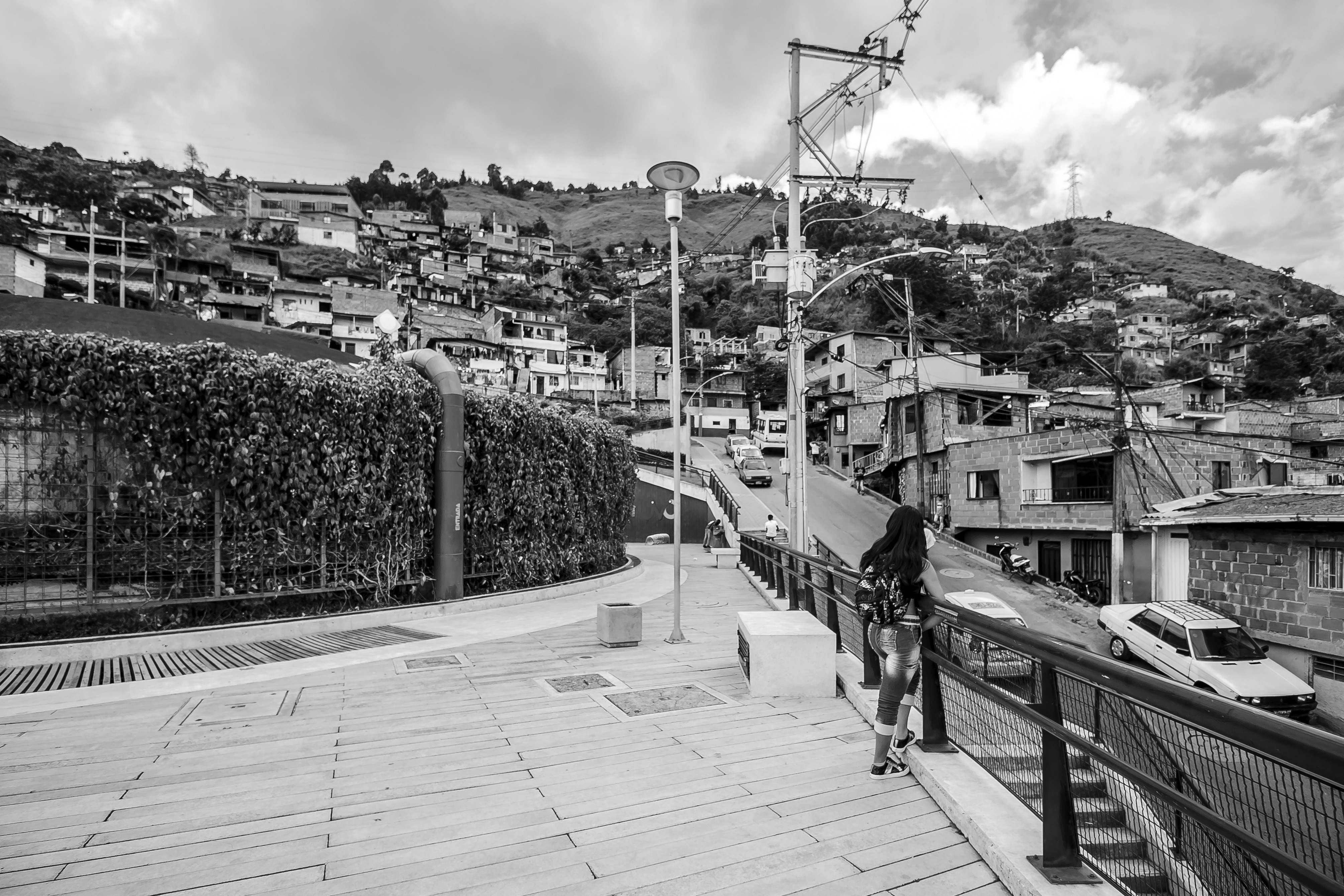
Another point of view regarding Metrocable (2003)
The Metrocable lines are part of the Aburrá Valley Integrated Transport System (Sistema Integrado de Transporte del Valle de Aburrá - SITVA) that connects ten municipalities of the metropolitan area of Medellin. SITVA has been implemented since 2003, as a mass transit system capable of reaching areas of difficult access with a marked topography. The Metrocable lines connect poor neighbourhoods on the outskirts of the city’s central metro lines. This results in an integration of these marginalised regions into the formal structure of the city, especially in terms of time, as these routes take approximately 15 minutes.
This is one of the greatest emblems of Medellín’s recent urban transformation. However, most publications on the subject induce a rhetorical synthesis, reducing it to a pragmatic connection between the formal and informal city through a simple technical apparatus. We can surpass this reading for at least two reasons:
First, because it is a much more complex socio-spatial challenge that required a long process from the system’s implementation, through the assessment of its effects. It was also necessary to use complementary urban planning and design tools to address the problematic dynamics triggered by the system’s implementation. For example, methodologies used by the Urban Development Company (Empresa de Desarrollo Urbano - EDU), Integral Urban Projects (Proyectos Urbanos Integrales - PUI), and Integral Neighbourhood Improvements (Mejoramiento Integral de Barrios - MIB), besides library parks, and other social and public facilities that include the dynamics triggered by Metrocable. After all, when introducing this transport system, the related urban interventions were as important as its functionality moving passengers. This brings to the fore different degrees of friction in the immediate socio-spatial relations, which can be mediated and boosted by the installation of large urban infrastructures.
Secondly, the Metrocable brings mobility and accessibility into the agenda concerning more subtle spatial and experiential aspects of continuity of the formal city and the development of these territories. That contributes decisively to defining the symbolic potential of integration for communities that suffer processes of socio-spatial exclusion and marginalisation. The elevated cabins allow a visual connection with the surroundings along the route. Their distance from the ground is not enough to isolate the sounds from music in bars, the streams (quebradas), the collective agitation in the schoolyards or the houses stacked horizontally and vertically on the slopes. The cabin holds a maximum of 10 people, providing an involuntary but curiously intimate, brief, and silent shared contemplation experience.
When arriving at the Metrocable stations, it is clear that they are not just specialised technical infrastructure. The stations give rise to a meticulous level of transitional systems between the boarding platform, suspended nearly 15 metres, and its projection on the natural steep terrain (Figure 9). The design strategies of these architectural artifacts, as we can describe them, typically create countless possibilities for appropriation. For example, lookout terraces (Figure 8), small amphitheatres, and spaces for recreation that result in rare and valuable plains in a territory marked by hills. These characteristics relativised the mono-functionality of these artifacts and made the experience of using this means of transport worthy of a fully-entitled citizen. Furthermore, both the stations and the cabins become elements incorporated into the real and affective landscape of these neighbourhoods, besides unveiling visuals never collectively enjoyed before.


The ease of access to these parts of the city, the search for the experience of using Metrocable, and the new public facilities built around the stations attract tourists and residents of other regions of the city. This contributed to breaking the isolation and closure that once characterised life in these areas. It has also contributed to opening new horizons for young residents, fostering a sense of pride in belonging to a neighbourhood in the north-western sector of the city. This is because the Metrocable, the library park, and the perception of greater security by the presence of the State (through infrastructure) bring the notion of actual participation in the city’s future, as discussed by Leibler and Brand (2012). Their interviews with the local population raised aspects of great social impact, although difficult to measure.
Contradictions in the production of urban space naturally arise in these interventions. New dynamics of urban precariousness with new irregular occupations can be seen around these new public spaces and stations. The intervention also promoted real estate appreciation and an increase in the cost of living in the neighbourhood. These phenomena indicate engagement with the aggressive urban-land market dynamics so inherent to the formal city.
Awaiting opportunities for the UVAs, 2014
The Articulated Life Units (Unidades de Vida Articulada - UVAs) built by the Public Companies of Medellín (Empresas Públicas de Medellín - EPM) are scattered on the city slopes. EPM, provider of electricity (energy generation and distribution), sanitation, waste collection, gas, and telecommunications services, proposed transforming the land where UVAs were later built in 2014. Most of it comprised water tanks located on walled sites. With relatively simple architectural design interventions, such as the removal of walls, protection of technical areas, and construction of terraces, these sites became part of the public facilities network. They were transformed into open spaces and squares to host recreational and cultural programmes. The interventions are usually organised in small volumes built under or around large walkable surfaces surrounding the tanks (Figure 10). These volumes house multipurpose rooms for courses, recreational activities, small auditoriums, and other functions subordinate to the main purpose of the open areas.

This network contributed to democratising access to these services, reaching neighbourhoods traditionally marked by poverty and lack of public amenities or suitable public spaces. Like Metrocable, UVAs put into perspective the relationship between the city’s major infrastructure and the necessary reinterpretation of its interactions with the urban fabric. Remarkably, the water supply system ended up revealing a new system of open public spaces in the city, when it was no longer interpreted only by its technical attribution – a typical limitation imposed by institutional constraints or by sectorial policy regulations. This system also became a lively attraction, integrating a set of symbolic spaces in Medellín (Figure 11). The views in each of the 18 UVAs make them unique, attracting visitors from other locations (Figure 12 and Figure 13).


A path containing the city’s future: Jardin Circunvalar, 2014
Figure 14:
View of the UVA Sol de Oriente (left) and the inner city (in the middle of the photo) from the Jardin Circunvalar (Source: The author).

The UVAs planning process revealed features in the city edges that could offer public enjoyment of the environmental resources. Under these circumstances, the Bypass Garden (Jardín Circunvalar - JC) was designed as a tool in the Land Use Regulation Plan (Plan de Ordenamiento Territorial - POT). It is the first part of a larger metropolitan park implemented in the municipality of Medellín, the Metropolitan Green Belt of the Aburrá Valley (Cinturón Verde Metropolitano del Valle de Aburrá - CVMVA). Therefore, it has a dual function: a public space and a boundary to contain occupation on the city’s borders.
This idea dates back to the city’s first POT in 1999. However, the initial intentions were reinforced in 2006 by the Metropolitan Planning Guidelines and the revision of the municipality’s POT in 2014 (Acuerdo 48, 2014). In the last two years, the Metropolitan Region of the Aburrá Valley, the municipality of Medellín, through the “Metropolitan Borders Plan” (Plan Bordes Metropolitano) and the CMVA, carried out the planning, design, and execution of the interventions in this area. The JC at Comuna 8 was the first section implemented between 2014 and 2015 by EDU, comprising a path connecting eight neighbourhoods around the Pan de Azúcar hill. It takes advantage of pre-existing rural trails that have been rehabilitated and improved. The “path” design uses simple resources to overcome the topography, enhancing the crossing of green areas with stairs, bridges, viewing platforms, bike paths, racetracks, courts, squares, urban furniture, lighting, and pergolas. These elements are articulated with no access control. They are not defined as a park or as an autonomous unit, separated from the urban reality by grids or controlled by opening hours.
From an urbanistic abstraction (delimiting the urban perimeter), we move directly to the sensitive and comprehensive dimension of a leisure amenity: a paved path that connects three other parks above the hill. As we walk through the Jardín Circunvalar, we can also think of the city’s image construction. The scale of Medellín is easily understood because of its valley condition and its many high viewing points, such as the two hills that meet in the central area (Nutibara and Volador). Besides, the slopes always allow the visualisation of the dense and vertical urbanised central area (Figure 7), the river as an infrastructure vector, the dense and informal edges to the north, the isolated high-end residential towers to the southeast, the poorly verticalized neighbourhoods, and more homogeneous neighbourhoods to the southwest. Therefore, the urban morphology reading, and geography interact and enable a mental and potentially collective construction of Medellín.
Conclusions
In São Paulo and Medellín, the deployment of urban infrastructure included intensity and speed to interact with the world’s economic systems. This process strategically defined the current conflicting urban structure and dynamics, distancing them from a fair city. Neither urban regulatory frameworks nor trends arising from the real estate market offered a consistent alternative to this disarticulation and systemic segregation of the territory. These problems are rooted in political and economic imperatives. However, architecture and urbanism tools can play a crucial role as an alternative and immediate reaction, putting in motion a different reading of the existing urban morphology that can interact and enable a mental and potentially collective construction of the city. Although the demonstrative examples here are different, they share three essential postures:
First, they recognise the real urban matrix attending to an urge to recover an understanding of territorial dynamics after a demographic explosion and appeasement of urban dysfunction processes. This disciplinary encounter with the real urban matrix can sew its complexities to unveil a new landscape. Especially in the case of the urban peripheries, this approach can break the closure and isolation of these areas, reclaiming them as part of the city.
Secondly, it proved to be fundamental to reconnect urban plans and projects.8 Advancements in regulatory frameworks, urban instruments, and sectoral policies interacting with the territory are not enough to reconcile the socio-spatial demands of daily life. Only urban design and architecture tools can act on strategic morphological aspects of the urban fabric crisis.
These aspects were more evident concerning infrastructural systems. The related urban intervention was as crucial as the functionality of the infrastructure facilities, giving them the sensitive and comprehensive dimension of a leisure amenity. Therefore, the third posture is the need to reconcile infrastructure and territory, potentialising their social transformations rather than their efficiency. The reality of accessing them must provide an experience worthy of a fully-entitled citizen, contributing decisively to the symbolic potential of integrating communities that suffer socio-spatial exclusion and marginalisation processes.